NASA radar maps new view of World Heritage Site
 Washington, Jan 28: In just two 10-minute overflights, an airborne NASA radar has pinpointed areas of disturbance in Peru’s Nasca lines World Heritage Site. The data collected on the two flights will help Peruvian authorities fully catalog the thousand-year-old designs drawn on the ground in and around the site for the first time.
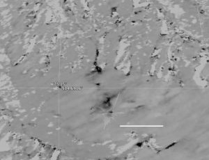
It will also give them a new tool for protecting the fragile constructions from both careless humans and natural disturbances such as floods. A shape called the Hummingbird is faintly visible above and to the left of the scale line, its long beak ending below a road that cuts diagonally from the right edge of the image to the centre.
“In the synthetic aperture radar image of the same site, right, areas of disturbance appear dark. There are extensive areas of disturbance around the Hummingbird as well as a pathway down the gully directly above the glyph. Other small disturbances may have been caused by erosion in the dry creek beds,” the US space agency said in a statement.
NASA’s Uninhabited Aerial Vehicle Synthetic Aperture Radar (UAVSAR) can record changes on the ground beneath the aircraft that occur between multiple flights which take exactly the same flight path. The instrument is used to monitor how volcanoes, earthquakes, and other natural hazards are changing Earth.
“The UAVSAR is ideally suited for observing the Nasca site because the region has virtually no vegetation and receives no rainfall whatsoever in most years, meaning that natural disturbances are minimal,” said principal investigator Bruce Chapman.
The UAVSAR images of the site appeared in a paper in the journal Conservation and Management of Archaeological Sites. (IANS)